
UAV Based Agricultural Planning and Landslide Monitoring
Abstract
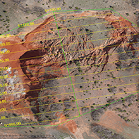
The use of Unmanned Aerial Vehicle (UAV) tools has become widespread in map production, land surveying, landslide, erosion monitoring, monitoring of agricultural activities, aerial crop surveying, forest fire detection and monitoring operations. In this study, GEO 2 UAV manufactured by TEKNOMER equipped with SONY A6000 camera has been used. The flight plan have been performed with 100 m altitude, with 80% longitudinal and 60% side overlapping. Ground Control Points (GCPs) have been observed with Topcon and Trimble GNSS geodetic receivers. Recorded GNSS signals have been processed with LGO V.8.4 software to get sensitive location information. 985 photos have been taken for the 344 hectares the agricultural area. 291 photos have been taken for 50 hectares the landslide area. All photos were processed by PIX4D software. For the agricultural area, 25 GCPs and for the landslide area, 8 GCPs have been included in the evaluation. 3D images were produced with pixel matching algorithms. As a result, the RMS evaluation was obtained as ±0.054 m for the agricultural area and as ±0.018 m for the landslide area. UAV images have indisputable contributions to the management of catastrophes such as landslides and earthquakes, and it is impossible to make terrestrial measurements in areas where disaster impact continues.Downloads
References
Ackermann, F. (1999). Airborne laser scanning - Present status and future expectations. ISPRS Journal of Photogrammetry and Remote Sensing, 54(2-3),64-67. doi:http://dx.doi.org/10.1016/S0924-2716(99)00009-X
Aktug, B., Kılıcoglu A. (2005). Time Evolution of Reference Systems and A National Model For Turkey. TUREF‐96 (Turkish National Reference System‐96). Earthquake Symposium, Kocaeli, 269‐274, March 23‐ 25, 2005. (In Turkish). Retrived from http://www.koeri.boun.edu.tr/astronomy/pektas/papers/Ito_BSSA2002_92_418.pdf
Baltsavias, E.P. (1999). A comparison between photogrammetry and laser scanning. ISPRS J. Photogramm. Remote Sensing 54, 83-94. doi:http://dx.doi.org/10.1016/S0924-2716(99)00014-3
Belardinelli, M.E., Sandri, L. & Baldi, P. (2003). The major event of the 1997 Umbria Marche (Italy) sequence: what could we learn from DInSAR and GPS data? Geophys. J. Int. 153 (1), 242-252. doi:http://dx.doi.org/10.1046 / j.1365-246X.2003.01908.x
Chang‐Chun L., Guang‐Sheng Z., Tian‐jie L. & A‐du G. (2011). Quick image‐processing method of UAV without control points data in earthquake disaster area” Trans. Nonferrous Met. Soc. China, 21,s523–s528. doi: https://doi.org/10.1016/S1003-6326(12)61635-5
Carter, W.E., Shrestha, R.L. & Slatton, K.C. (2007). Geodetic laser scanning. Physics. Today ,60 (12), 41-47. doi:https://doi.org/ 10.1063/1.2825070
Chidburee, P., Mills, J. P. Miller, P. E. Fieber K. D. (2016) The International Archives of the Photogrammetry, Remote Sensing and Spatial Information Sciences, Volume XLI‐B5, 2016 XXIII ISPRS Congress, 12–19 July 2016, Prague, Czech Republic. Retrived from: https://www.int-arch-photogramm-remote-sens-spatial-inf-sci.net/XLI-B5/
Cheok, G.S., Leigh, S. & Rukhin, A., (2002). Technical report: calibration Experiments of a Laser Scanner. US National Institute of Standards and Technology, Report No NISTIR, 6922. Retrived from: https://archive.org/stream/calibrationexper6922cheo/calibrationexper6922cheo_djvu.txt
Davies, T. (2015). Chapter 1 - Landslide Hazards, Risks, and Disasters: Introduction, Landslide Hazards, Risks and Disasters. Academic Press, Boston,1-16. ISBN 9780123964755
Dikau, R., Cavallin, A., & Jäger, S. (1996). Databases and GIS for landslide research in Europe. Geomorphology, 15, 227–239. doi:https://doi.org/10.1016/0169-555X(95)00072-D
Dunford R, Michel K, Gagnage M, et al. (2009). Potential and constraints of Unmanned Aerial Vehicle technology for the characterization of Mediterranean riparian forest. International Journal of Remote Sensing ,30,4915–4935. doi: https://doi.org/10.1080/01431160903023025
Francisco‐Javier, F, Carrascosa, M, García, M D.N, Meroño de Larriva, J.E. & García‐Ferrer, A. (2016). An Analysis of the Influence of Flight Parameters in the Generation of Unmanned Aerial Vehicle (UAV) Orthomosaics to Survey Archaeological Areas, Sensors 2016, 16(11), 1838. doi:http://dx.doi.org/10.3390/s16111838D
Guzzetti, F., Reichenbach, P., Cardinali, M., Ardizzone, F., & Galli, M. (2003). The impact of landslides in the Umbria region, central Italy. Natural Hazards and Earth System Sciences,3, 469–486. Retrived from: https://hal.archives-ouvertes.fr/hal-00299056/document
Henry, J.-B., Malet, J.-P., Maquaire, O. & Grussenmeyer, P. (2002). The use of small-format and low-altitude aerial photos for the realization of high-resolution DEMs in mountainous areas: application to the Super-Sauze earth-flow (Alpes-de-HauteProvence, France). Earth Surf. Process. Landforms 27 (12), 1339. Retrived from: https://halshs.archives-ouvertes.fr/halshs-00260644/file/2002Henry_et_al_ESPL.pdf
Hunt, R., Hıvely, D., Fujikawa, S.J., Linden, D., Daughtry, C., & Mc Carty, G. (2010). Acquisition of NIR‐ Green‐Blue Digital Photographs from Unmanned Aircraft for Crop Monitoring, Remote Sensing, Volume. 2,290‐305. doi:https://doi.org/10.3390/rs2010290
Jaboyedoff, M., Oppikofer, T., Abellán, A., Derron, M.H., Loye, A., Metzger, R., & Pedrazzini, A. (2010). Use of LIDAR in landslide investigations. a review. Nat Hazards,61(1),5–28. doi: https://doi.org/10.1007/s11069-010-9634-2
Jones, L.D. (2006). Monitoring landslides in hazardous terrain using terrestrial LiDAR. an example from Montserrat. Q J Eng Geol Hydrogel 39(4),371–373. doi:https://doi.org/10.1144/1470-9236/06-009
Kauai, H.I., Basagni, S., Petrioli, C. & Spenza, D. (2016).The Collection Tree Protocol in Wake-up Radio WSNs for Critical Applications, in Proceedings of IEEE ICNC 2016,1-6. doi:https://doi.org/10.1109/ICCNC.2016.7440687
Laliberte, A.S., & Rango, A. (2009). Texture and scale in object-based analysis of subdecimeter resolution unmanned aerial vehicle (UAV) imagery. IEEE Transactions on Geoscience and Remote Sensing ,47, 1–10. doi: http:/dx.doi.org/10.1109/TGRS.2008.2009355
Laliberte, A.S, Herrick, JE, Rango A, et al. (2010). Acquisition, orthorectification, and object-based classification of Unmanned Aerial Vehicle (UAV) imagery for rangeland monitoring. Photogrammetric Engineering and Remote Sensing ,76,661–672. doi:https://doi.org/10.14358/PERS.76.6.661
Leprince, S., E. Berthier, F. Ayoub, C. Delacourt, & Avouac, J.-P. (2008). Monitoring Earth surface dynamics with optical imagery, Eos Trans. AGU, 89(1), 1, doi:http:/dx.doi.org/10.1029/2008EO010001
Lichti, D.D., Gordon, S.J. & Tipdecho, T. (2005). Error models and propagation in directly georeferenced terrestrial laser scanner networks. Journal of Surveying Engineering,131(4),135-142. doi:https://doi.org/10.1061/(ASCE)0733-9453(2005)131:4(135)
Lindner, G. (2013). Einsatz von Unmanned Aerial Vehicles“im Bereich des alpinen Naturgefahrenmanagements anhand von ausgewählten Beispielen. Master thesis, BOKU University of Natural Resources and Life Sciences Vienna. Retrived from: https://forschung.boku.ac.at/fis/suchen.orgeinheit_betreuungen?sprache_in=de&menue_id_in=206&id_in=H871
Lindner, G., Schraml, K., Mansberger, R. et al. (2016). UAV monitoring and documentation of a large landslide. Applied Geomatic March 2016, Volume 8, 1–11. doi:https://doi.org/10.1007/s12518-015-0165-0
Lucieer A, Turner D, King DH, et al. (2014). Using an Unmanned Aerial Vehicle (UAV) to capture microtopography of Antarctic moss beds. International Journal of Applied Earth Observation and Geoinformation.,27(Part A),53–62. doi: http://dx.doi.org/10.1016/j.jag.2013.05.011
Mazzanti, P., Bozzano, F, Cipriani, I.., & Prestininzi, A. (2014). New insights into the temporal prediction of landslides by a terrestrial SAR interferometry‐monitoring case study. Landslides, Volume 12, 55-68. doi:https://doi.org/10.1007/s10346-014-0469-x
Niebergall, S., Loew, A. & Mauser, W. (2007). Object-orientated analysis of very highresolution QuickBird data for mega city research in Delphi/India. In Urban Remote Sensing Joint Event,1-8. doi:https://doi.org/10.1109/URS.2007.371836
Nex, F. & Remondino F. (2015). UAV For 3D Mapping Applications.: a review. Applied Geometrics, 6,1-15. doi: https://doi.org/10.1007/s12518-013-0120-x
Niethammer, U., Rothmund, S. and Joswig, M. 2009. UAV-based remote sensing of the slow-moving landslide Super-Sauze. In: Malet, J.-P.,Remaître, A., Boogard, T. (Eds) Proceedings of the International Conference on Landslide Processes: from geomorpholgic mapping to dynamic modelling, Strasbourg, CERG Editions: 69-74. Retrived from: https://pdfs.semanticscholar.org/2c32/527e28abf3603d4c934274cb9a375ba7e75e.pdf
Niethammer, U., James, M.R., Rothmund, S., Travelletti, J., & Joswig, M. (2012). UAV‐based remote sensing of the Super‐Sauze landslide. evaluation and results. Engineering Geology, 128,2–11. doi:https://doi.org/10.1016/j.enggeo.2011.03.012
Niethammer, U., James, M.R.R., Rothmund, S., Travelletti, J., & Joswig, M. (2010). UAV‐ based remote sensing of landslides. International Archives of Photogrammetry, Remote Sensing and Spatial Information Sciences, Vol. XXXVIII, Part 5 Commission V Symposium, Newcastle upon Tyne, UK. Retrieved from: https://pdfs.semanticscholar.org/2c32/527e28abf3603d4c934274cb9a375ba7e75e.pdf
Peppa M. V., Mills J. P., Moore P., Miller P. E., Chambers J. E. (2016). Accuracy assessment of a UAV based landslide monitoring system, The International Archives of the Photogrammetry, Remote Sensing and Spatial Information Sciences, Volume XLI‐B5, 2016 XXIII ISPRS Congress, 12–19 July 2016, Prague, Czech Republic. doi:https://doi.org/ 10.5194/isprsarchives-XLI-B5-895-2016
Pirotti, F., Guarnieri, A., Vettore, A., (2013). State of the art of ground and aerial laser scanning technologies for High-resolution topography of the Earth Surface. European Journal of Remote Sensing, 46(1), 66-78. doi: https://doi.org/10.5721/EuJRS20134605
Rau, J.Y, Jhan, J.P., Lo, C.F., & Lin, Y.S. (2011). Landslide Mapping using imagery acquired by a fixed‐wing UAV. ISPRS - International Archives of the Photogrammetry, Remote Sensing and Spatial Information Sciences, Volume XXXVIII-1/C22, 195-200. doi:https://doi.org/10.5194/isprsarchives-XXXVIII-1-C22-195-2011
Regmi, N.R., Giardino, J.R., McDonald, E.V., Vitek, J.D., (2015). Chapter 11 - A Review of Mass Movement Processes and Risk in:John R. Giardin and Chris Houser (Eds), Principles and Dynamics of the Critical Zone, Volume 19,319-362, Elservier, Amsterdam. ISBN: 978-0-444-63369-9
Remondino, F., Barezzetti, L., Nex, F., Scaioni, M., & Sarezzi, D. (2011). UAV Photogrammetry for Mapping and 3D Modelling. International Archives of the Photogrammetry, Remote Sensing and Spatial Information Sciences, Vol.38 (1/C22), Zurich, Switzerland. Retrived from: https://www.int-arch-photogramm-remote-sens-spatial-inf-sci.net/XXXVIII-1-C22/25/2011/isprsarchives-XXXVIII-1-C22-25-2011.pdf
Riedel, B., Walther, A. (2008). InSAR processing for the recognition of landslides. Adv. Geosci.,14.189-194. doi: https://doi.org/10.5194/adgeo-14-189-2008
Squarzoni, C., Delacourt, C., & Allemand, P. (2005). Differential single-frequency GPS monitoring of the La Valette landslide (French Alps). Engineering Geology, 79(3-4),215–229. doi:https://doi.org/10.1016/j.enggeo.2005.01.015
Rossi, G., Nocentini, M., Lombardi, L., Vannocci, P., Tanteri, L., Dotta, G., Bicocchi, Scaduto, G. Salvatici, T., Tofani, V,. Moretti, S. & Casagli, (2016). Integration of multicopter drone measurements G and ground-based data for landslide monitoring in Aversa et al. (Eds), Landslides and Engineered Slopes. Experience, Theory and Practice,1745-1750, Associazione Geotecnica Italiana, Rome. ISBN 978-1-138-02988-0
Schuster, R,L., & Fleming, W.F. (1986). Economic losses and fatalities due to landslides. Bulletin of the Association of Engineering Geologists ,23,11–28. doi:https://doi.org/10.2113/gseegeosci.xxiii.1.11
Sillard, P., Altamimi, Z., & Boucher, C. (1998). The ITRF96 Realization and Its Associated Velocity Field. Geophysical Research Letters, 25,3223-3226. doi:https://doi.org/ 10.1029/98GL52489
Sony Corparation User Manuel. Retrived from:http.//pdf.crse.com/manuals/4532055411.pdf
Stumpf, A., Malet, J.P., Kerle, N., Niethammer, U., & Rothmund, S. (2013). Image-based mapping of surface fissures for the investigation of landslide dynamics. Geomorphology ,186,12–27. doi: https://doi.org/10.1016/j.geomorph.2012.12.010
Stumpf, A., Malet, J.P., Allemand, P., & Ulrich, P. (2014). Surface reconstruction and landslide displacement measurements with Pléiades satellite images. ISPRS Journal of Photogrammetry and Remote Sensing, Volume 95, p. 1-12. doi:https://doi.org/10.1016/j.isprsjprs.2014.05.008
Tahar, K., Ahmad, A., Akıb, W.A., & Udın, W.S. (2011). Unmanned Aerial Vehicle technology for large scale mapping. ISG&ISPRS Conference; 2011 Sept. 27-29(2011). Shah Alam, MALAYSIA. Retrieved from: http://asiageospatialforum.org/2013/pdf/Noor%20Aniqah%20Mohd%20Azhar.pdf
Tofani, V., Segoni, S., Agostini, A., Catani, F. & Casagli, N. (2013). Technical note: Use of remote sensing for landslide studies in Europe. Nat. Hazards Earth Syst. Sci. , 13, 1–12. doi:https://doi.org/10.5194/nhess-13-299-2013
Turk, T., Görüm, T., Birdal, A.C., & Selçuk, O. (2015). Optical Satellite Images Investigation of Mass Movements in with Landslide Areas. The Case of the North Anatolian Fault Zone, TUFUAB VIII Technical Symposium, 21-23 May (2015), Konya. (In Turkish).
Tschari, A., Rumpler, M., Fraunddorfer, F., Mayer, G., & Bischol, H. (2015). On the use of UAV’s in mining and archaeology –geo-accurate 3D reconstructions using various platforms and terrestrial Views. ISPRS Annals of the Photogrammetry, Remote Sensing and Spatial Information Sciences, Volume II-1/W1, 30 Aug-02 Sep 2015 Toronto. Canada. Retrieved from: https://www.isprs-ann-photogramm-remote-sens-spatial-inf-sci.net/II-1-W1/15/2015/isprsannals-II-1-W1-15-2015.pdf
Nex, F. & Remondino F. (2015). UAV for 3D mapping applications: a review. Applied Geometrics, 6,1-15. doi:https://doi.org/ 10.1007/s12518-013-0120-x
Van, Den Eeckhaut, M.V., Poesen, J., Verstraeten, G., Vanacker, V., Nyssen, J., Moeyersons, J., Beek, L.P. & Vandekerckhove, L. (2007). Use of LIDAR-derived images for mapping old landslides under forest. Earth Surf. Process. Landforms ,32 (5), 754-769. doi: https://doi.org/ 10.1002/esp.1417
Van, Den Eeckhaut M, Poesen J, Verstraeten G, Vanacker V, Moeyersons J, Nyssen J, & Van Beek L.P.H. (2005). The effectiveness of hillshade maps and expert knowledge in mapping old deep-seated landslides. Geomorphology, 67,351–363. doi:https://doi.org/10.1016/j.geomorph.2004.11.001
Walter, M., Niethammer, U., Rothmund, S. & Joswig, M. (2009). Joint analysis of the SuperSauze (French Alps) mudslide by nanoseismic monitoring and UAV-based remote sensing. EAGE First Break, 27 (8), 75-82. Retrieved from: http://eost.u-strasbg.fr/omiv/Publications/Walter_et_al_2009_FirstBreak.pdf
Wester-Ebbinghaus, W. (1980). Aerial photography by radio controlled model helicopter. Photogramm Rec,10,85–92. doi: https://doi.org/10.1111/j.1477-9730.1980.tb00006.x
Yıldırım, O., Susam, T., Yaprak, S., Delen, A., & Inyurt, S. (2016). The Availability of UAV Systems for Agricultural Purposes. Journal of Agricultural Faculty of Gaziosmanpasa University, (33)-3,111-120. doi:https://doi.org/10.13002/jafag1127
Yılmaz, R., & Yılmaz, O. (2016). Determination of the Vital Ecological Networks. The Case of European Side of Turkey. Journal of Environmental Protection and Ecology, 17,No 4, 1603-1611(2016)
Zillman, J. (1999). The physical impact of disaster. In: Ingleton J (ed.) Natural Disaster Management. Leicester: Tudor Rose Holdings Ltd.Leicestr,pp 320.
Copyright (c) 2017 Tema. Journal of Land Use, Mobility and Environment

This work is licensed under a Creative Commons Attribution 4.0 International License.
Authors who publish in this journal agree to the following:
1. Authors retain the rights to their work and give in to the journal the right of first publication of the work simultaneously licensed under a Creative Commons License - Attribution that allows others to share the work indicating the authorship and the initial publication in this journal.
2. Authors can adhere to other agreements of non-exclusive license for the distribution of the published version of the work (ex. To deposit it in an institutional repository or to publish it in a monography), provided to indicate that the document was first published in this journal.
3. Authors can distribute their work online (ex. In institutional repositories or in their website) prior to and during the submission process, as it can lead to productive exchanges and it can increase the quotations of the published work (See The Effect of Open Access)