
Analyses and Surveys on Urbanized Areas through MIVIS Techniques: Data Classification Applied to the City of Pomezia, Rome.
Abstract
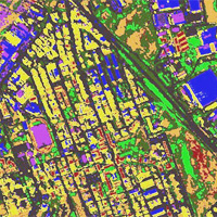
This paper is aimed at investigating, in an original and innovative manner, a portion of the territory of the Municipality of Pomezia (Rome) by means of remotely sensed data. The airborne MIVIS (Multispectral Infrared and Visible Imaging Spectrometer) imagery was acquired from an altitude of 1 500 m. In fact, the high spectral and good spatial resolution of the MIVIS sensor allowed to provide important information helping us study and better understand complex and diversified situations, such as anthropized areas.
The site taken into consideration for this study belongs to the city of Pomezia. Founded more than 70 years ago, Pomezia, originated as rural suburb, has become an important industrial district of Lazio Region territory thanks to its location near Rome and to the fund for the development of Southern Italy. This led to a massive industrialization up to the 90s, a period when industrial activities and urban areas evolved very rapidly without, or in part without, a urban planning followed by a progressive de-industrialization process which is still under way.
MIVIS data processing technique, through the classification of objects and materials within urban areas, allowed us to discriminate, with a good level of detail, the distribution of the different spectral classes. Moreover, from a first reading of the View Statistics Files, we can deduce considerations on the evolution of the territory, emphasizing some important environmental aspects, such as the diffuse waterproofing of soils. In fact, we can notice a situation of messy urban and industrial areas growth with high percentages of waterproofed surfaces that are impossible or difficult to reverse. This is a serious environmental issue which led to the loss of vegetation surfaces, increasing negative effects both on the biodiversity and landscape quality which bring about the dissipation of valuable resources, such as the soil, that will represent a serious concern for the environment in the future.
Downloads
References
Barberis R., 2005 - Consumo di suolo e qualità dei suoli urbani. Qualità dell’ambiente urbano II Rapporto APAT, Edizione 2005, pp. 703-729.
Ben-Dor, E.; Levin, N.; Saaroni, H. (2001) A spectral based recognition of the urban environment using the visible and near-infrared spectral region (0.4–1.1 m). A case study over Tel-Aviv. International Journal of Remote Sensing 2001, 22 (11), 2193–2218.
Bianchi R., Cavalli R.M., Fiumi L., Marino C.M., Pignatti S. Pizzaferri G. (1996) 1994/1995 CNR LARA Project airborne hyperspectral campaigns. Proceedings of Eleventh Thematic Conference and Workshops Applied Geologic Remote Sensing, Las Vegas, Nevada USA, pp. 301-310.
Bonora N. Marinosci I., Munafò M. (2008) Qualità dell’Ambiente Urbano, V Rapporto ISPRA Roma.
Brivio P.A:, Lechi G., Zilioli E. (2006) Principi e metodi di telerilevamento Edizioni Città Studi.
Bruno A. (1981) Materiali da Costruzione, Edizioni medicea, Firenze.
De Angelis D., (2004) Tirrena a Pomezia Ed.-Isa Pomezia.
EEA (2006) European Environment Agency, La sovra crescita urbana in Europa, 2006 04 EEA briefing ISSN 1830-2319.
Fiumi L. Rossi S. (2007) Dalla cartografia storica al telerilevamento: la città di Roma, Edizione Pagine-CNR, Roma, 2007.
Herold, M., Gardner, M., & Roberts, D. (2003) Spectral resolution requirements for mapping urban areas. IEEE Transactions on Geoscience and Remote Sensing, 41(9), 1907−1919.
Heiden, U.; Segl K.; Roessner S.; Kaufmann H.(2007) Determination of robust spectral features for identification of urban surface materials in hyperspectral remote sensing data. Remote Sensing of Environment 2007, 111, 537–552.
ITT (2008) Visual Information Solutions.ENVI - Environment for Visualizing Images, Version 4.4, 2008. Available at: www.ittvis.com/envi
Mazzeo G., (2009). Dall’area metropolitana allo sprawl urbano: la disarticolazione del territorio. TeMA 04.09, Trimestrale del Laboratorio Territorio Mobilità e Ambiente, ISSN 1970-9870Vol 2 N.4 Dicembre 2009, pagg. 7-20.
Mariani R., (1976) Fascismo e ‘Città Nuove’, Feltrinelli, Milano.
Montano C., (2008) Piano del Colore del Centro Storico di Pomezia.Studi storici e rilievi diagnostici. ( a cura di) Palombi Ed. e Comune di Pomezia.
Nuti L., (2001) La città nuova nella cultura urbanistica e architettonica del fascismo, da Metodo, n. 17/2001.
Pennacchi A., (2010) Canale Mussolini, Mondadori, Milano.
Pennacchi A., (2011) Fascio e Martello, Laterza, 2011.
Pignatti S., (2009) “Le città di fondazione non sono un bene ‘usa e getta’” Convegno: Città di Fondazione, politiche per la città ed antropizzazione tra fascismi e democrazie, Università IUAV di Venezia, Ca’ Tron, Venezia.
Provincia di Roma (2011) Rapporto Annuale. La situazione della Provincia di Roma.
Sessa A., (1990) Pomezia – Origini, genti, personaggi, Capriotti Ed., Pomezia.
Yuhas R.H. , Goetz A.F.H., Boardman J.W. (1992) Descrimination among semiarid landscape endmembers using THE Spectral Angle Mapper (SAM) algorithm. Summaries of the Third Annual JPL Airborne Geoscienze Workshop, 1 june, Pasadena, CA, Jet Propulsion Laboratory, 147-149.
Copyright (c) 2014 Tema. Journal of Land Use, Mobility and Environment

This work is licensed under a Creative Commons Attribution 4.0 International License.
Authors who publish in this journal agree to the following:
1. Authors retain the rights to their work and give in to the journal the right of first publication of the work simultaneously licensed under a Creative Commons License - Attribution that allows others to share the work indicating the authorship and the initial publication in this journal.
2. Authors can adhere to other agreements of non-exclusive license for the distribution of the published version of the work (ex. To deposit it in an institutional repository or to publish it in a monography), provided to indicate that the document was first published in this journal.
3. Authors can distribute their work online (ex. In institutional repositories or in their website) prior to and during the submission process, as it can lead to productive exchanges and it can increase the quotations of the published work (See The Effect of Open Access)